How to field survey highway steps
Scenario
One is out on the field and comes across a path on OpenStreetMap that has a set of steps. One chooses to create a survey field note.
At a later date, one processes the survey notes and realizes that one is having trouble georeferencing the details. Thus all the effort becomes useless in the betterment of OpenStreetMap.
Solution
With the utilization of the BFS field surveying heuristics (BFS FSH)1 one creates concrete reusable field notes.
BFS field surveying steps heuristic
The BFS field surveying steps heuristic is a schema for highway=steps.
The field note schema is
1step <count> <?interval> <?direction> <?incline>
With properties
<count>: equates tosteps_count=<count>.<?interval>(optional): eithera|alphaoro|omegaA , sometimesifor intermittitur (Latin: it is interrupted).<?direction>(optional): cardinal directionB . Avoid using degrees, since the number can be confused with the step count.<?incline>(optional): equates toincline=<incline>, specifically eitherupordown.
The properties are commutative.
Conventions
There are multiple conventions to adhere to.
Standalone
The standalone convention requires a reference pointC . It utilizes almost all properties. It does not have a more concrete length and needs to be estimated when post-processing.
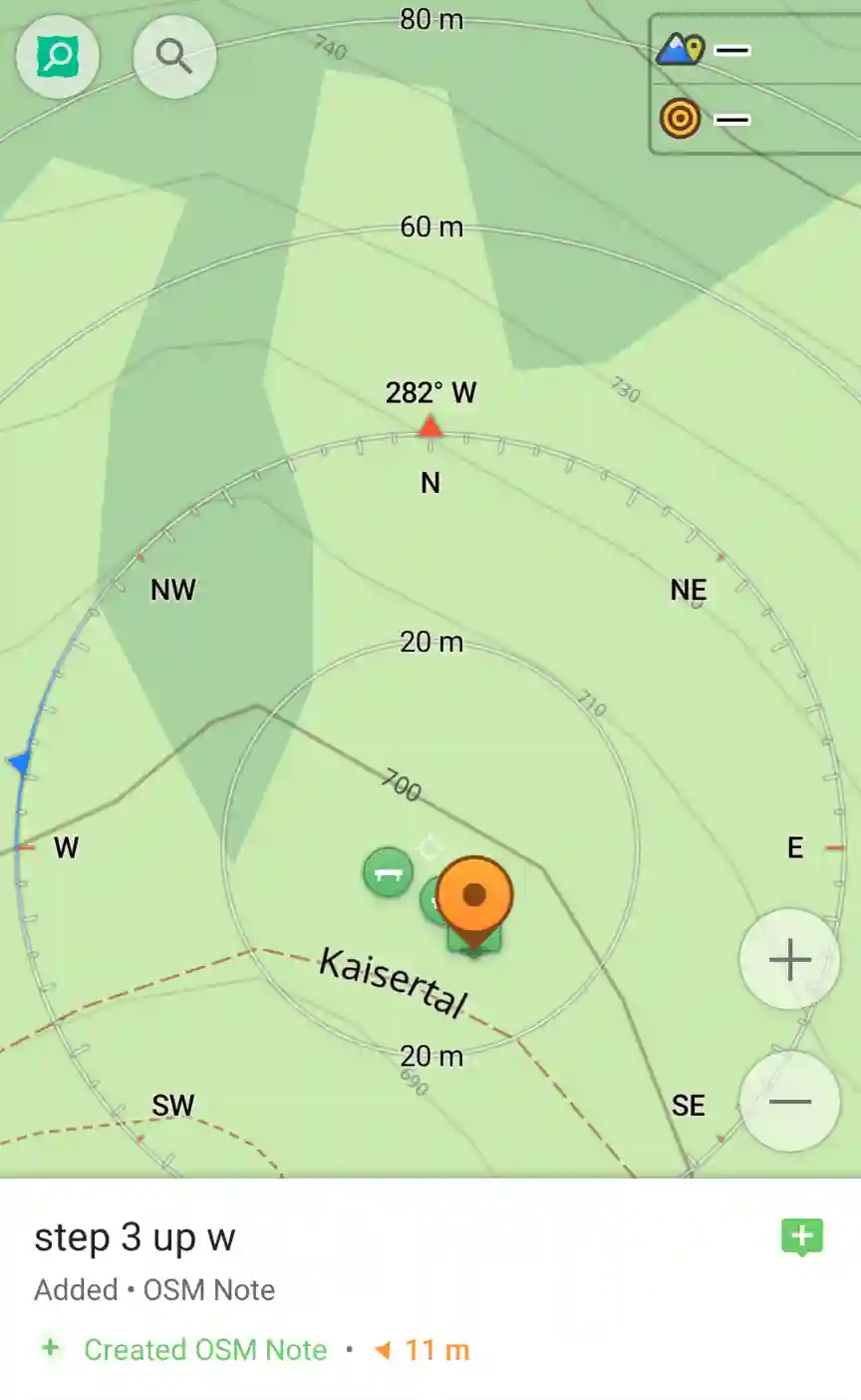
Example
In the image, the GPX track is flowing from SE to W, thus one utilizes the track as a reference point and realizes that the steps are a part of the path.
Next one creates an arbitrary long way and gives it the properties:
1highway=steps
2steps_count=3
3incline=up
The direction of the way is W.
Interval
The interval convention sets either incline=up or incline=down as the default state. It requires a reference pointC
. It requires a start and end point, thus the length of the way is more concrete.
In the case that the incline is opposite of the default incline, make sure to denote this alteration. The preference is to use the end point.
If the steps count is known, then add this detail at the end point.
If the steps count exists, then there is no need to add the extra information of o|omega to the end point.
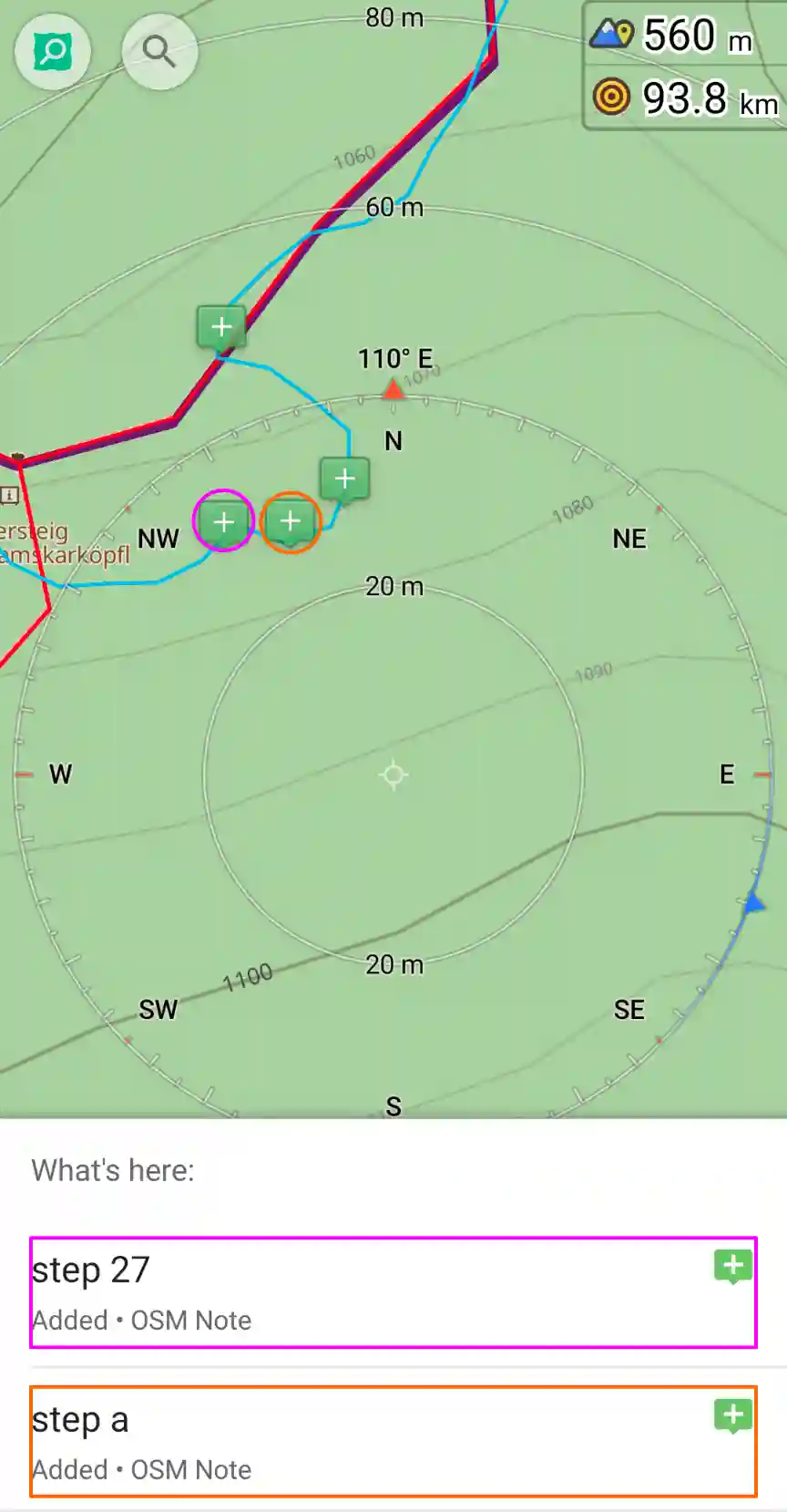
Example
In the image, although existing path data existed (colored as red or purple), the tracked (colored as blue) route diverges from the existing ones. The GPX track is flowing from N to W and the default incline=up.
In this case, first one aligns the existing way with the newly tracked route. Next one makes two new point insertions and splits the way into three parts. The centered part is updated to highway=steps. Additionally, add steps_count=27 and adjust the direction of the way to equate to incline=up.
Additional keywords
right|left|both|center: the highway has a handrail positioned athandrail=right|left|both|centerrespective to the reference point.ramp: the highway has an integrated ramp,ramp=yes.ramp separate: the highway has a separate highway for the ramp,ramp=separate.bridge: the highway has a bridge,bridge=yes.<SURFACE>: the surface of the highway.
Evaluation of the heuristic
- The direction removes the ambiguity that may come from not precise note placement while in the field.
- The direction removes remembering what right/left means when reflecting back on the moment.
- The direction is not dependent on the screen orientation aligning with north.
- Using cardinal directions quickly surveys the steps without requiring the phone to be orientated towards the path.
- Using the standalone convention provides enough details without meticulously needing to denote the start and end points of the steps.
- Using the interval convention creates a more concrete length and placement of the steps.
- Using count quickly adds the
steps_countand removed the need to denote the end point. - Using incline removes the need to remember the default incline.
- To avoid mixing up various default incline choices, one should set the default in the first note of the session/day e.g.
default=up. - Without a reference point it is hard to deduce if the steps are a straight line or if it has multiple breakpoints.
References
- Definition "interval", BFS FSH ↩︎
- Definition "direction", BFS FSH ↩︎
- Definition "reference point", BFS FSH ↩︎
-
BFS field surveying heuristics (BFS FSH) cookbook, BFS Source, ↩︎